On 23 January 2025, ICCROM, in partnership with the Ministry of Culture and Strategic Communications of Ukraine (MCSC), the Maidan Museum, the Agency for Cultural Resilience (ACURE), and the Heritage Emergency Rescue Initiative (HERI), officially launched the GIS-Based Risk Map for Cultural Heritage in Ukraine. This pioneering tool, developed by ICCROM’s First Aid and Resilience for Cultural Heritage in Times of Crisis (FAR) programme, marks a significant milestone in the effort to safeguard Ukraine’s cultural heritage amid ongoing conflict and environmental risks.
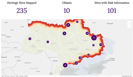
Supported by the US Department of State and the US Embassy in Kyiv, the Risk Map combines cutting-edge geospatial technology, open-source data, and on-the-ground assessments to provide a strategic, data-driven approach to risk management for cultural heritage. By analyzing over 230 heritage sites across ten oblasts, the tool empowers decision-makers, cultural professionals, emergency responders, and researchers to prioritize protection efforts, enhance emergency responses, and develop long-term recovery strategies for heritage in Ukraine at risk.
A Data-Driven Approach to Risk Management
Since 2023, ICCROM and its partners have conducted extensive training, on-site damage and risk assessments, and leveraged GIS mapping, satellite imagery, and risk modelling to develop this platform. Key milestones include:
Training of 25 cultural first aiders (August 2023) from five at-risk oblasts— Kharkiv, Odesa, Donetsk, Chernihiv, and Kyiv— in post-event damage assessments using ICCROMFAR’s web and mobile-based app.
On-site expeditions for conducting post-event on-site damage and risk assessments across 18 heritage sites in four at-risk oblasts: Khmelnytskyi, Kherson, Donetsk, and Zaporizhzhia.
Multi-source data triangulation from 60+ national and international partners, integrating local field reports, satellite imagery, and predictive risk modelling to provide a comprehensive risk overview through the GIS-based Risk Map.
Expert Insights from the Panel Discussion: The Role of Risk Mapping in Safeguarding Cultural Heritage
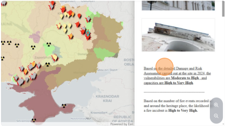
The discussion explored how GIS-based risk mapping strengthens data-driven decision-making, enhances emergency response, and supports policy integration for cultural heritage protection. Speakers highlighted the need for reliable digital documentation to inform national and international legal frameworks and stressed that Ukraine’s approach could serve as a model for integrating heritage risk mapping into broader governmental planning. It was also emphasized Ukraine’s leadership in heritage risk preparedness, underscoring the importance of risk maps for climate resilience and strategic resource planning and outlined how satellite-based monitoring, through Copernicus and Galileo, enables real-time risk assessment and supports decision-making for heritage protection. The scientific methodology behind risk calculations was also outlined, detailing hazard probability, exposure, and structural vulnerability.
The panel concluded with a call for expanded GIS training for Ukrainian professionals, enhanced legal recognition of digital documentation, stronger collaboration between heritage and emergency response sectors, and continuous updates to the Risk Map to ensure its long-term impact.
A Collaborative Effort for Long-Term Impact
The GIS-Based Risk Map marks Phase I of a four-phase initiative to assess, protect, and recover Ukraine’s cultural heritage. ICCROM and its partners will expand its coverage, provide advanced GIS training, enhance data-sharing with UNESCO and ICOMOS, and integrate risk mapping into national emergency plans. Now live, the map is a valuable tool for heritage professionals, researchers, and decision-makers.
Now live, the map is a valuable tool for heritage professionals, researchers, and decision-makers. ICCROM thanks all contributors and invites further engagement
Explore the Risk Map and Learn How You Can Contribute
For further details on this initiative, contact the FAR Programme at: far_programme@iccrom.org